-
 ErdasIMG: Conversion between LAN or GIS (Erdas) files and IMG
Direct access to online help: ErdasIMG
Access the application from the menu:
"File | Import | Rasters | LAN/GIS (Erdas 7.4) -> IMG"
"File | Export | IMG -> LAN/GIS (Erdas 7.4)"
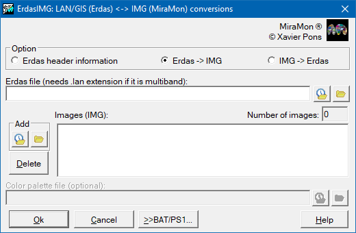
Presentation and options
This program allows putting several IMG files into one Erdas file of type LAN or GIS. On the other hand, it can also extract all the image bands contained on a LAN file and save them into different IMG files. GIS files only have one band and they are usually thematic files, not radiometric images.
ErdasIMG:Conversión entre ficheros LAN o GIS (Erdas) y IMG:
El programa permite tomar la información de cabecera del fichero Erdas y la presenta de una manera ordenada.
ErdasIMG:Conversión entre ficheros LAN o GIS (Erdas) y IMG:
El programa permite tomar ficheros de Erdas de tipo LAN o GIS y convertirlos en IMG
ErdasIMG:Conversión entre ficheros LAN o GIS (Erdas) y IMG:
El programa permite tomar distintos ficheros IMG y poner-los en un solo fichero ERDASS de tipo LAN o GIS.
In the conversion from GIS to IMG, if a TRL file, containing the color palette and the class names, exists, a file P25 with the palette will be created; class names are stored in the DOC file.
In the conversion from IMG to GIS, DOC file categories are written into the TRL file, as well as palette colors, that are extracted from the P25 file given at the command line.
This program runs with Erdas files version 7.4 .
The Erdas format is appropriate to work with Erdas, Arc/Info and
ArcView.

Dialog box of the application
Syntax:
ErdasIMG Option Erdas_File.LAN IMG_File_1 [IMG_File_2,
...IMG_File_n]
ErdasIMG Option Erdas_File.GIS IMG_File [P25_File]
- Option can be
- 0: Information about the Erdas file header.
- 1: Conversion Erdas -> IMG.
- 2: Conversion IMG -> Erdas.
- Erdas_File is the name of the Erdas file and must be given with
extension (LAN o GIS).
- IMG_File_x are the names of the IMG raster files.
- P25_File is the name of the color palette file in P25 format. By
default is the neme of IMG_File.
Notes:
- When using Option 1, the number of IMG files will depend on how many
bands the Erdas file contains: if it is of GIS type, only one; if it is
of LAN type, you should first run ErdasIMG Option 0 to obtain this
information.
- In Option 1 for GIS files, if TRL file is not found then no palette
will be written (P25_File name is ignored).
Erdas, Arc/Info and ArcView are registered trademarks of their respective owners.