-
 KMLMM: Import and export between KML and MiraMon format
Direct access to online help: KMLMM
Access the application from the menu:
"File | Import | Vectors and/or databases | KML, KMZ (Google Earth) -> MMM (PNT, ARC/NOD, POL)"
"File | Export | MMM, PNT, ARC, POL -> KML, KMZ (Google Earth)"
Presentation and options
This application imports and exports between the KML format of GoogleEarth and MiraMon.
Option 0: KML file contents information:
CONTENTS INFORMATION: Shows a list of the KML or KMZ file contents. It reports the number of KML objects of type 'Point', 'LineString' and 'Polygon'.
Option 1: Importation to MiraMon format (without topological structuring).:
Converts a GoogleEarth KML file into MiraMon Maps which contain layers in MiraMon structured format (PNT, ARC/NOD and POL).
Option 2: Export from MM to KML:
Convert a MiraMon Map file or a MiraMon vector file (PNT, ARC, POL or VEC) to a KML file.
The application creates a map with a point layer (PNT), which contains the 'Point' type KML objects, a (ARC/NOD) line layer for KML objects of the 'LineString' type and a layer of polygons that contains the 'Polygon' type objects, if there are any. 'MultiGeometry' and 'LinearRing' type objects that are not part of a polygon are ignored. If there is information regarding the z of each vertex, it is also converted. The layers are not structured topologically.
The 'id' attribute and the 'name', 'description' y 'styleUrl' elements of each KML object are included. They are all added to the main table of each layer as thematic attributes under the names: ID_ENTITAT, NOM, DESCRIPCIO e ID_ESTIL.
The map allows you to open all the layers created with symbolization, which for lines and polygons depends on the field values 'ID_ESTIL' and for the points is a radius point 3 with a text with the value of the 'NOM' attribute of the object.
All the objects of any KML file are in latitude/longitude projection with WGS84 datum, but the application allows you to reproject the map layers to any of the reference systems described in the MiraMon geodesic tables.

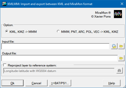
Dialog box of the application
Syntax
Syntax:
- KMLMM 0 KMLFile
- KMLMM 1 KMLFile MMMFile [/SIST_DEST]
- KMLMM 2 MMFile KMLFile
Options:
- 0:
Information on the file contents
- 1:
Importation to MiraMon format (without topological structuring).
- 2:
Export from MiraMon to KML
Parameters:
- KMLFile
(KML File -
Input parameter): KML or KMZ file with .kml or .kmz extension
- MMMFile
(MMM File -
Output parameter): Is the name, with .mmm extension, of the output file. The program creates a directory with the same name as the map, and the same level where it saves the map layers using the following nomenclature: PNT_KMLMM, ARC_KMLMM and POL_KMLMM.
- MMFile
(MM File -
Input parameter): MiraMon map (.mmm) or vector (.pol, .arc, .pnt or .vec) file.
Modifiers:
/SIST_DEST=
(Reference System)
Identifier of the reference system in which you wish to reproject the layers. Its default value is 'lat/long-WGS84'. (Input parameter)