-
 CalcGeo: Geodetic calculator
 CalcGeo: Geodetic calculator
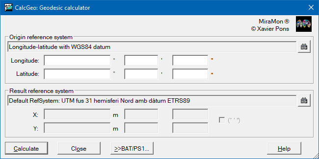
| Presentation and options | Dialog box of the application |
| Syntax |
A reference system is defined by a projection, a set of parameters for this projection (for example, a reference parallel), a datum and an ellipsoid and usually involves a considerable number of parameters. These parameters can be found in the geodesic tables or they can be directly specified in the REL file. The definition of a reference system is a complex process and must be done only once for each new system that is wanted to be used; in addition, MiraMon is distributed with a broad set of commonly used reference system definitions. The document Horizontal reference systems in MiraMon. Tables and files of geodesy can be consulted for more information.
For systems in angular coordinates (latitude and longitude), such as the Equirectangular, these can be given in degrees or in degrees, minutes and seconds. Negative quantities must be used for longitudes west of Greenwich and latitudes south of the equator. If the angular quantities are negative, the sign will be associated with the largest non-zero magnitude, p. eg: -5° 25' 43.6", 0° -3' 45.5", 0° 0' -5.3".
All calculations are made in double precision (with a minimum of 15 significant figures) and the results in meters and millimeter accuracy (3 decimals) are shown for projections in linear coordinates, and in degrees and precision of ten-thousandths of a second for projections in angular coordinates.
If the projection system "UTM (automatic spindle and hemisphere)" is chosen, the program will automatically choose the spindle and hemisphere that correspond to the geographical point specified in the input coordinates.
Advanced use: CalcGeo is a tool focused on transforming isolated points. If it is necessary to convert large amounts of data, a BAT file for mass execution (discussed below) can be generated or, alternatively a file of points or lines (PNT, ARC/NOD or VEC) can be generated and use the CanviPrj application to transform the whole layer at the same time (remember that in order to convert polygon layers (POL) its corresponding arc layer has to be converted since in the structured model of MiraMon each polygon is formed by the reference to one or more arcs). As mentioned before, a BAT file can be built to convert a small sequence of points. This BAT file will specify each of the point-to-point executions; a perfectly tabulated results list will be obtained by redirecting the output to a text file (with the character ">") and using the /BAN parameter to exclude the header. A small example with two points: file "transfor.bat":
By executing the command line "transfor >result.txt", the file "result.txt" will be obtained:@echo off CalcGeo lat/long 40 30 UTM-37N /BAN CalcGeo lat/long 40 29 UTM-37N /BAN
Equirectangular (Latitude/Longitude in degrees) --> UTM-37N
        lon:40.00000000 lat:30.00000000 -->     X:596454.290    Y:3319254.527

Equirectangular (Latitude/Longitude in degrees) --> UTM-37N
        lon:40.00000000 lat:29.00000000 -->     X:597406.730    Y:3208443.687
More information can be consulted at the following reference:
Pesquer L, Pons X, Masó J (2005) Necesidad de cálculos geodésicos para las herramientas SIG de análisis de distancias y superfícies. 6th Geomatic Week proceedings (ISSN 1699-3489). Barcelona.
 |
| CalcGeo dialog box |