 |
MiraMon products and license types: registration, purchase and download |
| MiraMon products and license types | How to register at MiraMon |
| Buy / download MiraMon products |
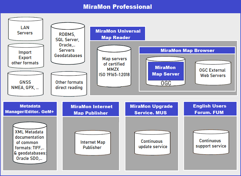
MiraMon products and license typesThe MiraMon product family consists of:  MiraMon professionalIt is the desktop application and the most powerful of them all. Here are described some aspects of basic settings such as display, query and print, a variety of tools for exchanging data between formats, some topics in geometry and geodetic mapping, spatial analysis, remote sensing tools, documentation and cataloging metadata, use of GPS and automatic creation processes. It is a 32-bit and 64-bit application that can be run on Windows platforms, from version 95 to W10, programmed in ANSI C language in its entirety. Currently there are three types of MiraMon license that allow the installation of the program: Generalitat de Catalunya license: Free version of MiraMon for exclusive use in the Public Administration, research centers, land stewardship network and students in Catalonia. To have this license it is necessary to be previously registered in the Generalitat de Catalunya license. Academic license: Free version of MiraMon for the exclusive use of students and schools. To have this license it is necessary to be previously registered in the MiraMon Academic License. Complete license: Paid version of MiraMon for other users. A full professional license in any of its types can be purchased by clicking on: The main functionalities of the professional MiraMon are: Visualization: For raster, vector and a combination of both, as well as with requests from OGC WMS Layers (WMS, WMTS, WFS and WCS). It also enables 3D visualization perspectives. Raster: MiraMon own file formats include bit, byte, integer, real, long, extracompressed or plain files, as well as RGB combinations of any of them. You can directly open JPEG, JPEG2000, JPC, J2C, MrSID, GeoTIFF, ECW, BMP, RLE, DIB and import/export PGM or PPM, CEOs or NDF, TIFF + DIMAP of SPOT, HDF, ASCII, E00 , RST, LAN / GIS, GRD, CTL, RF, etc formats. MiraMon treats BMP, JPEG, MrSID and JPEG2000 files as an own format with their complete metadata. Vector: MiraMon own file formats may have topological structure with the advantage that this represents: speed, connection to databases, more complex analysis, maintaining topological relationships (connection of islands groups, knowledge of gaps within polygons, etc). MiraMon vector formats are: PNT, ARC, NOD, POL and VEC. You can directly open SHP, DXF, DGN, GPX and KML format files and tables containing x and y fields. These files can be 3D and multi-Z for each coordinate. Geodatabases: MiraMon allows reading and importing ESRI ArcSDE geodatabases to MiraMon structured files preserving the Z for each coordinate, the attributes, relational databases, etc. Query: It allows to perform queries by location and by attributes on raster and vector layers, retrieving information directly from DBF or from a relational database through ODBC on MS-Access, MS SQL Server, Oracle, Informix, etc. Digitizing and topological building: Allows on-screen digitizing over raster, vector, geoservers WMS/WMTS, etc. Can generate layers of points, arcs and polygons. Graphic objects from other layers can be copied directly (with or without their attributes) in the layer being digitized. MiraMon has several editing vector tools for connecting vertices and segments (SNAP), partition, union, and elimination or displacement of vertices, and the possibility of changing the attributes with a simple click or dragging attributes from the legend. It permits construction of a real topology on points, arcs and polygons layers that are saved as structured binary vector. While other software force the user to stop scanning whenever an intersection of lines is produced, MiraMon calculates these intersections on the fly and creates new nodes if necessary. It also allows, if desired, dynamic topological structure digitization! Unrivaled for teaching and for generating rigorous layers, without errors, with greater ease than in any other program. Different polygon limits in multiple layers can be defined in a single layer of arcs, drastically reducing the space in disk and contributing to the consistency of the database. It has also advanced topology tools allowing the possibility of using tolerances: micropolygons elimination, shorten or lengthen arcs, pseudogeneralization of lines, removal of end nodes and arcs, etc. GNSS: Data from the GNSS receiver can be acquired in two major ways: in real time, acquiring, visualizing track and showing various parameters of the acquisition, or later connecting the GNSS receiver to the computer. Browse in real time with the GNSS connected to the computer, allows to be located on maps in an opened session of MiraMon and draw a phenomenon while on the terrain. The other option allows loading and unloading items in the case of receivers such as Garmin GPS. MiraMon performs direct reading and importing of the GPX format. Cartographic geometry and geodesy: MiraMon can support and carry out conversions (of single coordinates or whole layers) between the most common cartographic projections, as well as datum transformations (Molodensky and Bursa-Wolf). It can also visualize the Cartesian coordinates of the projection (UTM X, Y, etc) and/or latitude/longitude coordinates, reference networks and tics. It is possible to personalize new projections and the most accurate geodesic aspects are respected thanks to its complete model. Satellite images and aerial photographs can be converted into orthophotomaps using Digital Elevation Models and accurate algorithms by means of an easy-to-use interface. The resulting orthoimages displayed have a high degree of coincidence among themselves and with other graphic layers. It is ideal for time series studies based on old or recent aerial photographs or on satellite images. These algorithms are also used to geometrically correct digital maps scanned from paper originals. Analysis: There are more than 100 analytical tools. Among them, the more basic ones are the layer calculator and reclassifier that includes reclassification and mathematical and logic operations in a single expression and environment; and the analytical layer combination that allows you to combine layers and obtain new layers or tables with crossed statistics. All these tools accept raster and/or vector layers and tabular data. The alphanumeric data tables are not limited, neither in the number of fields, nor in the length of the text fields, nor in the characters to write the field names, etc. Also, the relationship between spatial features can be 1 to many (a variable number of records associated with the same spatial feature). Other MiraMon tools include size pixel changes, scaling and translating, buffers and distance maps, mosaicking and clipping layers, 2D and 3D point or arc interpolation (trend surfaces, inverse distance splines, kriging, neighbor statistics) to generate maps of variation (elevation and bathymetry, temperature, pollution, etc) and terrain analysis (elevation, slope, orientation, lighting, shading, solar radiation, etc.), vector network analysis according to distance and travel time, analysis of friction and travel costs, calculation of multiple regression models, geostatistic analysis of the variogram, geometric elementary transformations, cartographic generalization, contour line generation, and much more. Most of these tools can work simultaneously with raster and vector layers and take in consideration the existence of NODATA values. Remote sensing: Remote sensing is present in MiraMon since the beginning. It has specially designed tools: orthorectification of satellite images and aerial photographs, radiometric correction, standard metadata for sensor and platform, multiband support, unsupervised classifiers and mixed classifiers (supervised and unsupervised), Artificial Intelligence classifiers like kNN, confusion matrices generation, selective filters, calculations of emissivity and surface temperature, and much more. Data Manager and Catalogue: MiraMon incorporates two different tools in order to have the maximum documentation about our layers. On one hand there is the Metadata Manager (GeMM) that allows us to generate, edit and save metadata and relationships with other databases of a layer or, even, a cartographic series. The GeMM follows the INSPIRE Directive and complies with the standards (ISO 19115, FGDC, etc.) so that it is possible to export in HTML or XML format (IDEC, ISO 19139). Unlike other simply documentary applications, GeMM controls consistency, verifying the consistency of the data. With well documented layers, we have easy and quick access through the MetaDades Catalog, ideal when there is a large volume of maps located in different locations. The Metadata Catalog consists of an application designed according to the schema and elements Core ISO 19115 and a web interface for viewing them, customizable through HTML and XML templates and easily accessible (SQL does not need to be known) without losing potential: searches by geographical area, by hierarchy, sensitive or not to capitals and accents, etc. In addition, the creation and partial or total update of the catalog can be carried out automatically. Printing: High-quality maps of any size (A0, A1, etc) can be created interactively and easily while maintaining total and strict control of the map view (scale, extension, etc). Finished maps can be printed on paper, on Enhanced Metafiles (EMF), Windows Metafiles (WMF), high-resolution bitmaps (BMP, JPEG) or can be copied to the windows clipboard as an EMF or WMF formats so that maps can be added to a report. Once they are on the clipboard, they can be pasted perfectly into other applications (maintaining the original scale, colors and quality of the vectors and rasters). Once a map has been composed, it can be enlarged or reduced to fit any paper size. Using the printing assistant, it is possible to quickly create maps with all the most common elements (graphic and numerical scale, north arrow, legend, date and time, etc). You can increase productivity if you have templates created in your own style. With advanced printing parameters and selecting personalized paper sizes for your computer, it is possible to create large wallmaps. Metadata Manager/Editor. GeM+GeM+ is a powerful and intuitive application that allows you to create, manage and edit metadata from very diverse sets of geographic information, whether we have access to the data or not. If we have data access (for example, to a TIFF that contains an image of interest) the GeM+, which is able to read the most common formats, will dynamically transfer to the metadata some information extracted from the data itself, thus avoiding transfer errors and keeping the information always consistent and automatically updated. This will help in increasing the productivity of your metadata editing. Allows to document XML metadata of geographic information datasets available in any of the usual formats (such as a TIFF) or in a geospatial database (Oracle SDO). In case we don't have access to the data we can also type in all the information like in the old conventional editors. Allows to work offline without an Internet connection. GeM+ is distributed at no cost and does not require installation. For more information see Metadata Manager and Editor. GeM+ or the documents listed in the section Universal Geospatial Metadata Manager from the MiraMon Help Guide. MiraMon Universal Map ReaderThe MiraMon Universal Map Reader is a FREE program that allows to view, query and print maps published on the Internet . The application can be run on Windows platforms, from version 95 to W10, programmed in ANSI C language in its entirety. The reader has the following properties:
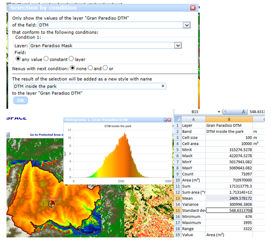
Click here to see some examples. To download the MiraMon Universal Map Reader click on MiraMon Map Browser and ServerThis technology allows to bring your maps to the Internet with nothing else than the usual web browser. It's very easy to use and it offers high-quality detailed maps combined with analytical and statistics capabilities, following the most common OGC standards. Some examples of the MiraMon Map Browser can be seen here. The MiraMon Map Browser is a long term developing effort to create a visualization, analysis and download tool that runs in modern web browsers. Only based on HTML5 and JavaScript it uses Open Geospatial Consortium web service protocols to connect to web services and show the information to the user. The JavaScript client is able to combine AJAX, binary arrays and the WMS/WMTS protocol. In the case of remote sensing data, the information is structured in coverages. The objective of the development is to assign to the web browser and the JavaScript engine as much work as possible, limiting interactions to the server the minimum possible and the transfer of information to a format that is as raw as possible. This approach can be surprising, these days where many applications prefer to perform processing functionalities in the cloud and not by the client machine. Most of the time, the MiraMon Map Browser is the direct responsible to create the visualization on the fly based on the raw data, allowing the user to change visualization properties, perform analysis, statistics or build time series in the client side directly. The user is able to perform queries to the data in a more dynamic way, apply spatial filters, enhance contrast, changes palettes, create diagrams (e.g. histograms and pie charts), generate animations and graphics of a time series, and performing complex calculations among the bands of the different available datasets. Several layers of data coming from different servers and using different protocols can be overlaid simultaneously. Some layers represent data from a single dataset while other can be virtual datasets computed on the flight for each zoom and pan, and created by combining data form more than one dataset and server. The legend has two functions: on one hand, it provides information on the visualized information in the map view and on the other provides control to what is going to be visualized.
Basic functionalities: Advanced functionalities:   The MiraMon Map Server is a stand-alone CGI application that runs on Windows operating systems that can be used in combination with a web server such as Internet Information Server or Apache for Windows. It is the ideal solution for people that already uses MiraMon professional on desktop because it uses the same MiraMon formats in the back-end. MiraMon server is based on the same libraries that are used by MiraMon professional and has the same capabilities in terms of CRS support, interpolation algorithms, MMZX compression, etc. One particularity of the software is the internal tiled schema required to serve maps and tiles in a fast and scalable way. MiraMon Server uses OGC web services as a baseline for the interaction to the client. Currently, MiraMon server provides support for the following standards:
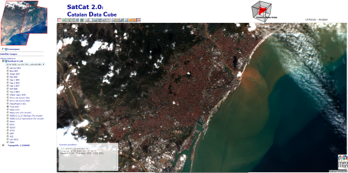
The MiraMon Server Sensor Observing Service (SOS) capacity is used in tandem with the Web Feature Service and uses the same MiraMon topologically structured formats in the back-end. It has been developed in the Ground Truth 2.0 project to server interoperable data from the Citizen Observatories created during the project. The current implementation is incomplete and only supports GetFeatureOfInterest and GetObservation operation with limited capabilities. The objective of the minimum capabilities developed was to respond to the requirements of a viewer client needs to represent a map of the features of interest provided by the service and to allow for a query in a point to get more information about the observations there. Each dataset in MiraMon becomes an observedProperty in the SOS service. Each observation is a position in a PNT file that has a DBF record associated that is transformed to an O&M DataRecord automatically. Internally, it is possible to mark field names in the DBF that are associated to concepts in the O&M such as the phenomenon time and the user name. Data Cube Technology (Open Data Cube) is a system developed to easy access, manage and analyse a multidimensional cube (x, y and t bands) of RS data. The main idea behind the datacube chases after minimizing the required knowledge to access and process remote sensing data and work efficiently with time series, thus transforming how users interact with large spatio-temporal RS data. In fact, the Open Data Cube is an open source initiative participated by several organizations from CEOS to CSIRO. The DC is based on a set of Python libraries and PostGreSQL database that helps on working with geospatial rasters, with special emphasis on analysis ready data.  GitHub code repository: Go to the MiraMon Map Browser GitHub following this link. MiraMon Internet Map PublisherIn order to publish maps on the Internet that can be free viewed with certification of authorship and integrity with the MiraMon Map Reader, you need to acquire a license of the MiraMon Internet Map Publisher. There are two ways to generate certified MMZ files, publishable on the Internet. Punctual certification This option is suitable if you want an occasional publication of a small number of maps. In this case you can create with the MiraMon Professional each map (MMM files) that you want to publish, convert them into MMZ files and send them by email or ftp, indicating which name you want to show in the certification. We will return them certified and ready for use in your HTML pages on the Internet-Intranet. Permanent certification This option is suitable for making an unlimited publication of maps in your name. We will send to you an application to certify as many maps as needed. In this case you don't need to have any additional interaction with us, which allows to generate certified maps even dynamically on demand from an HTML form.  . .
MiraMon Upgrade Service. MUSMiraMon is a software in constant development. The MiraMon Upgrade Service (MUS) is a support mechanism that allows the registered users to upgrade the MiraMon application and its additional modules (MSA) themselves using only a web browser. In the MiraMon versions diary there are listed the improvements, corrections, etc. that the MiraMon team of programmers develops. All changes and enhancements incorporated into MiraMon are documented and available in the MiraMon Update Service (MUS). This service is targeted only to the registered users of MiraMon Professional. Users of the MiraMon Map Reader can also get new versions of the Reader from the MiraMon Map Reader portal. MiraMon Users Forum. FUMMiraMon provides users with an environment where they can make inquiries and contributions openly to the entire community of MiraMon users through the MiraMon Users Forum, which is available in Catalan, Spanish and English. Registered users can post new topics in the Forum, reply to posts from other users, search for published topics, etc. How to register at MiraMonIn order to be able to access one of the two types of MiraMon license that allow the free installation of the program, it is necessary that the user is previously registered. Therefore, this step must be taken by those users who are not yet registered, otherwise you can go directly to the section Buy / download MiraMon products.. Registration process under the license of the Generalitat de Catalunya (only available for Catalonia) 1. Go to the MiraMon website https://www.miramon.cat/download/index_ca.htm and click on "Registra't a la llicència MiraMon Acadèmic. 2. Indicate to which group it belongs (Administration, University or Research Center, Xarxa de Custòdia del Territori or Student), declare (if applicable) that the activity is carried out in Catalonia and select the version of the product desired (download online or on CD-ROM). 3. Provide the data in the corresponding form. 4. Proceed to download the MiraMon license, following the instructions provided in the email provided in the registration process.< Registration process under the MiraMon Academic license This step must be taken by those users who are NOT yet registered. 1. Go to the MiraMon website https://www.miramon.cat/download/index.htm and click on "Sign in for MiraMon Academic license". 2. Indicate which group you belong to (Student or Academic institutions) and select the version of the desired product (download online or on CD-ROM). 3. Provide the data in the corresponding form. 4. Proceed to download the MiraMon license, following the instructions provided in the email provided in the registration process. Buy / download MiraMon productsPurchase of the professional MiraMon (complete license)The acquisition of MiraMon can be done individually, with the purchase of a license, or in packages of 5, 10 or more licenses, through this MiraMon offers 3 types of license setup: Telematic license: License is activated and deactivated with an Internet connexion. There is no need for the computer that will run MiraMon to be connected to the Internet but, in this case, you will need access to another computer with Internet connection for transfering the activation files. It is the general recommended procedure and you must use it if have a PC without 3.5" diskette drive. Key diskette: A 3.5" diskette will be send to you that will contain the MiraMon license, which must be installed in the destination computer and which is specific for that computer. Corporative licence (also known as floating licence): For 10 or more computers in a LAN it is possible to obtain corporative licenses. These corporative licenses stay in the server and allow that any client connects and executes the application. The maximum number of clients simultaneously working is given by the contracted number of licenses. Once the license has been downloaded, you can proceed with the installation process. MiraMon professional (Generalitat de Catalunya license or Academic license) downloadIn the case of wanting to download a free MiraMon professional license (Administration, University or Research Center, Xarxa de Custòdia del Territori or Student in the case of the Generalitat de Catalunya license or Student or Academic Institution in the case of an Academic license) the user must be previously registered. Once registered, go directly to the Download section of the professional MiraMon (Generalitat de Catalunya license or Academic license). MiraMon Universal Map Reader downloadIn order to download the MiraMon Universal Map Reader go directly to the section MiraMon Universal Map Reader Download. Metadata Manager/Editor. GeM+ downloadIt is distributed free of charge and does not require installation. Download Metadata Manager/Editor.MiraMon Map Browser and Server downloadIn order to download the MiraMon Map Browser and Server go to MiraMon Map Server and Browser download. In order to download the MiraMon Map Server and Browser and Permanent certifier tool (Internet Map Publisher) go to MiraMon Map Server and Browser and Permanent certifier tool (Internet Map Publisher) download. MiraMon Internet Map Publisher downloadIn order to download a pack of 10 puntual certifications, go to Packs of 10 certifications of compressed MiraMon Maps (MMZ) download. In order to download the Permanent certification (Internet Map Publisher), go to Permanent certifier tool (Internet Map Publisher) download. In order to download the MiraMon Map Server license + Permanent certification (Internet Map Publisher), go to MiraMon Map Server license + Permanent certification (Internet Map Publisher) download. MiraMon Upgrade Service. MUS downloadin case of being a MiraMon registered user and have already been subscribed to the MiraMon Update Service, go to:
|